Field notes on birds.
With our northward path into Montana and southern Alberta, we had reached the southern-most extent of the breeding range for a number of birds that we are accustomed to seeing in the winter time. As we drove back from our foray into Yellowstone, a group of four sandhill cranes flew across the highway at an altitude of about thirty feet and a range of about fifty feet, giving us an excellent view. I checked the range map and discovered that while the breeding range is largely far to the north in Canada, there is an area on the eastern slope of the Rockies in Montana where they breed.
At Big Timber, while we sat watching the river, three spotted sandpipers regularly flew up or down the river in formation, about six inches above the water. As we went north and encountered the land of small, permanent wetlands, the number of species multiplied: Ringbilled gulls, Franklin gulls, avocets, black-necked stilts, whimbrels, all kinds of ducks, pelicans of course, Canada geese (yes, they are found in places other than parks), yellow-headed blackbirds, and I swear I saw some kind of rail run across a road. It was amazing how much birding can be done from a motor home traveling down the highway at 55 mph, but many of the wetlands were right along the shoulder and the added height of the motorhome is a viewing advantage. It also helps that I’m familiar with most of these species. Coming into Great Falls, I spotted what looked like a group of five egrets flying along a river. We have egrets at home, but in Montana? Sure enough, the range map says that Snowy Egrets breed in the area. New birds require a much longer look and there are plenty of birds I see that I can’t identify to my satisfaction.
Oh Canada. So far away from Apache Junction but now that we were in Montana, suddenly so close. For several years I have been plotting how to get to Drumheller, Alberta, and now was the time. Southern Alberta looks – surprise!—a lot like northern Montana. Slightly undulating prairie, not many people. However, this part of Alberta is in Canada’s south, her breadbasket, the closest thing to a suitable place to grow crops in the country. And grow crops they do, a lot of different ones. The great American agricultural states tend to specialize: Kansas has vast cornfields, Nebraska does corn along with soybeans, Montana does wheat, etc.
Along the highway from the Montana border to our first night’s stop in Dinosaur Provincial Park (a hint as to why I wanted to come to this part of the world) we identified flax, canola, potatoes, peas, sugar beets, corn, onions, alfalfa and several different cereal grains which I am not equipped to identify. You’ve never seen canola in bloom, you say? Here’s a photo of canola fields on both sides of the highway. Flax fields, of which I was unable to get a satisfactory photo at 60 mph, are the most incredible blue, like Cinderella’s gown, and when planted next to canola are even more spectacular. Somewhere in the section about our last trip to France there is a photo of a flax field if you’re really interested.

Dinosaur Provincial Park encompasses a large area of badlands through which the Red Deer River runs. Think South Dakota badlands but with a river and cottonwood trees. These badlands just happen to have sedimentary strata which were laid down at the time of the dinosaurs. Paleontologists really like it when Mother Nature does most of the work and erodes the strata down to where the fossils exist, kind of like what happens on the faces of these badlands bluffs.

This photo shows a structure built over a partially excavated dinosaur skeleton, to show what the paleontologists see on the discovery site.

Much of the park is closed to the public for obvious reasons, but you can take a bus tour which goes through some of the closed areas. On our way out to take the self-driving tour early in the morning, this doe and fawn decided that they needed to be elsewhere when I stopped to take a photo of the fawn nursing.

As it turns out, there are a number of different dinosaur fossil sites in Alberta and these canny Canucks have turned the ever-popular beasts into several minor tourist attractions along with one major, world-class museum, the Royal Tyrrell Museum at Drumheller, my long-sought dinosaur destination. Dinosaur Provincial Park gives you a good feeling for where dinosaurs are found. The Museum gives you the dinosaurs. It has one of the largest collections of dinosaur fossils in the world! Who wouldn’t want to see it? I have to say that my loving husband wasn’t entirely sure himself and was humoring me when he agreed to visit the Museum. In the course of the several hours we spent there, he became a convert. We should have planned two or three days, or I should say, two or three days in the off-season, because this is a very popular spot, especially for people with children, bless their little hearts. Anyway, here is a sample of the displays we saw. Most of them I cannot name, and you dear reader probably wouldn’t recognize the name anyway unless you are a real dino nerd.
This turtle-like creature was so-o-o cute.

I think these are theropods gamboling.

Here's a T Rex.


Hello Mr. Rex!

This is another cutie. Is he saying "Feed me?" Who could resist?


This photo doesn't due Black Beauty sufficient justice. A remarkably complete T Rex found in Alberta and also one of the smallest T Rex examples ever found. Beautifully displayed.

This is an ammonite, which is a fairly common fossil. Under certain conditions of fossilization, one may be turned into a lovely gem-like substance. In fact, these are mined as gems and jewelry is made from them.

Something that is hard to grasp is that most of these displays are the real deal—these are the fossilized bones. In the few cases where an incomplete skeleton must be displayed for some reason, the parts of the bones that were missing and substituted are in a contrasting color so it is obvious where the real ends and the replica begins. Similarly, in a couple of cases, a whole skeleton was cast from an original to make a striking display, and this too is also clearly pointed out. In one gallery, you can watch technicians prepare the fossils, carefully picking away the rock from the bone. Talk about a job requiring patience! Progress is probably measured in millimeters. Not something you want to rush.
Scattered throughout the galleries are stations where museum personnel are set up to demonstrate something. We enjoyed a nice long chat with a technician who was demonstrating up close the removal of rock from bone and how different acids are used to assist in the work as well as what tools are used. Let me also say that the museum has done a world class job in creating the displays and also the interpretive material.
In addition to the ever-popular dinosaur bones, the Tyrrell gives a large chunk of display space to fossils found in the Burgess Shale, which is on the British Columbia side of the Canadian Rockies, fossils from a much earlier era and which represent a fascinating multitude of sea life, pretty much all of which is extinct today.
There is a large gallery of later sea creatures, like plesiosaurus and a wonderful enormous crocodilian with a head about nine feet long. Yikes—who would ever go in the water if he was still around? These exhibits were dimly lit, with the skeletons mounted as if they were swimming and the viewer was also under the water, so I didn’t get any good images but let me say that they too were spectacular.
There is another gallery with little teeny fossils of plants and animals from an era which escapes me at the moment and these are gorgeous too, and people were spending time examining them just as much as they did the dinosaurs.
By the time we were two-thirds through the museum we were both beginning to wilt under the serious overload and I’ll admit that we staggered rapidly through the more recent eras. Fortunately we had already seen mammoths so we didn’t even pause in front of the beautifully posed complete skeleton. I’m sure we must have missed some things but our brains had absorbed all they could. And now Al understood why I had been trying to drag him to Drumheller for years and years.
Dinosaurs weren’t the only things we saw in Alberta. The enthusiastic lady at the Welcome Centre loaded us down with maps and information about what the province had to offer. Way too much to take in on one trip. Al did, however, note a few things that he was interested in seeing. Alberta wins the prize for the best roads of any area we’ve traveled thus far. And the province wins hands down the prize for the best signage we’ve seen anywhere. Everything that might be of interest to a tourist rates a blue sign on the highway, with the exact distance and, as applicable, what facilities (camping, boating, swimming, etc.) will be found when you get there. For every town on or near the highway, the services available will be noted. Billboards are virtually non-existent and these standardized signs take their place without being obnoxious. There is also apparently an annual competition for towns decorated with flowers, similar to something we had seen in France, and almost every town had an attractive welcome sign as you entered. It also seemed like every town had a museum of some kind. Al did enjoy his visit to the Lancaster Air Museum in Nanton, while I waited outside in the motorhome with a book, I’ll admit. But you can’t visit them all.
On our way to Dinosaur Provincial Park, we traveled some secondary roads, one of which took us through the little town of Harlowtown which had this electric locomotive displayed. For the rail buffs, this is an E575B which is the last GE electric locomotive of 116 once owned by the now-defunct Milwaukee Road. These locos were used on a 600-mile mountainous stretch of the St. Paul and Pacific Railroad. There was a major roundhouse at Harlowtown which was closed in 1974. The story of so many railroad towns. 
The area of badlands in which the dinosaurs are found is also an area where coal was mined until the railroads switched to diesel in the 1950’s. Several historical sites in the area have to do with coal mining. This suspension bridge over the Red Deer River led to a coal mine on the other side of the river from town. 
The Atlas Coal Mine boasts the only standing wooden coal tipple remaining in the province. If you look closely you might see the large-diameter guy wires that keep it standing. One can take a tour underground in the mine but we passed on this one. 
Nearby was an excellent example of the famous Alberta grain elevator, a wooden structure that once was a ubiquitous site in the province. The Canadian railways laid down an incredible number of miles of spur lines to service these grain elevators that were spread all across the province. Many of the elevators succumbed to fire and were replaced with the larger and homelier but probably more functional metal structures seen today. There is actually a museum of the Alberta grain elevator, but it was not near our route. These really are lovely structures and it was always a treat to see one looming up on the horizon across the prairie. 
Alberta doesn’t get a lot of rain in a normal year, of which this was not one, as evidenced by the flooded fields. In the early days, drought and the general lack of rainfall was a problem for the farmers. Several irrigation districts were formed and dams built to create reservoirs. About 90 years ago, someone’s bright idea was a several kilometers-long aqueduct to bring water to the farmer in the Brooks area. It turned out not to work very well and was abandoned after a very short time, to be replaced by a canal. Today the province touts it as being the largest concrete structure of its type in the world, but I’ve seen the Pont du Gard and trust me, there is no comparison.  There is a small Provincial Historical Site along one section of the aqueduct and there were wonderful drifts of a kind of wild blue peas blooming and perfuming the air along the banks of the adjacent canal.
The town of Lethbridge was worth a detour to see this railroad bridge, one hundred years old last year and still in use. It is said to be the longest and highest of its kind. Unfortunately we did not see a train going across it. It was way too long to fit into my camera's field of view but this gives you an idea of what it looks like.

As we left the province, we made one last detour to Writing-on-Stone Provincial Park, just north of the border. This park is in an area of stone outcroppings above the Milk River, which flows into Montana. It supposedly contains the largest collection of Plains Indian stone art in North America and has a quite new, quite state of the art visitor center with fascinating interpretive displays. Alas, the bus tour which gives access to the best examples of rock art was booked for the next couple of days and the hiking trail which provides access to some other examples was way longer than either of us could handle, especially with the hot weather. Fortunately we both enjoyed the visitor center displays and felt like it was a worthwhile side trip. 
We bought a little slice of riverfront property in Montana. Well, we didn’t exactly buy it outright, we just bought the rights to it for a few days but while it lasted, it was ours and we enjoyed it thoroughly. We didn’t plan this particular stop, but the first RV park we stopped at, in Billings, was full even at the outrageous prices it was charging. Al called a couple of other RV parks and was stunned at the prices they too were quoting. Even though he didn’t really want to drive much further because it had been a day with gusty crosswinds, when the lady at the Spring Creek RV Park and Trout Ranch in Big Timber said she had room and quoted a price substantially less than the other parks, he asked her to save us a place. When we drove into the park, it was love at first sight. Unlike most other parks, this one had the RV sites scattered around the edges of the property with trout ponds in the middle. It was only $4 more a night for a site along the river and Al agreed with no hesitation. The best choice he made all day.

This is the view upstream from our RV site.
Sitting and listening to the birds and the river and staring at the burbling water ten feet from our toes is the most relaxing activity imaginable. For the first complete day we never even left the site except to go to the office to sign up for more nights before someone bought our twenty-foot slice of riverfront out from under us. We watched fly fishermen floating down the river in rafts (catch and release only—do you think the fish have any fun?) and boys floating down the river in inner tubes, all without even wanting to leave our chairs.

This is the view across the trout ponds at sunrise.

One day we finally roused ourselves from the hypnotic trance induced by the rushing waters and went to Yellowstone. We'd both been there before and figured it hadn't changed too much, but what the heck, it was in the neighborhood and we'd probably kick ourselves if we didn't do it. Of course as soon as we got into the park, Al started grumbling about the crowds and the lines of ants filing up the trail or boardwalk to the roadside attraction. I have to admit it was a lot of driving through tree-lined corridors without much of a view because most of the park is on this high plateau. I did make him take the drive along the north rim of the "Grand Canyon of the Yellowstone". At the lower falls overlook we benefited from "the wisdom of the crowd" by seeing this osprey nest complete with two chicks high on a hoodoo above the river. We would have never seen it if we had been the only ones around as it was pretty far away as you can tell by the way that the telephoto on my poor little point-and-shoot was barely able to focus in on the chicks. The falls were nice too.


The big deal that sets Yellowstone apart is the thermal activity. We avoided the major spots like the Hot Springs and Old Faithful, but right along the road was this little hot springs bubbling away. If you look closely at the left side of the photo
you can see the whiff of steam it let off every few seconds.

I was determined to see some wild life and was forever imagining moose and heffalumps in the distance, which Al pooh-poohed constantly. Once I said that I saw a bison lying down, but he insisted it was just a pile of wood. Well, it looked just like this guy who was a little closer to the road.

Another example of the wisdom of the crowd is shown in the next image. If you look really really hard, there are a bunch of dots just this side of the river. These are a bunch of bison, a large herd in fact, something we probably wouldn't have noticed except that other people were stopped along the road and we tried to figure out what they were looking at.

One of the coolest things about the day was the flowers. Most of Yellowstone is at an elevation of say 7000 feet plus, and so July is prime wildflower season. The flowers were absolutely spectacular. The higher we went, the better the flowers. We had entered the park via the north entrance and exited via the north-east entrance and then drove over Beartooth Pass which goes up to over 10,000 feet, which meant that the flowers were the best of all up there. So were the views of the surrounding mountains. There was no way I could capture the mountains adequately with my camera and everyone knows what Montana mountains look like anyway--just look at any travel ad. I concentrated on the nearer-to-hand flowers but even here my photos only capture a tiny bit of the flavor of the meadows and roadsides--imagine whole hillside covered with these flowers and you'll start to get an idea of why we both were oohing and aahing along the entire drive. Who needs heffalumps when you have alpine flowers in their prime?


We may be out of touch for a while but I'll be accumulating blog entries while off-line.
We're currently at Sheridan WY and are heading north to Canada in a leisurely fashion. Even in South Dakota and Nebraska we found ourselves without cell phone coverage and you can't expect state parks (except in Texas) to have wifi, so we were without internet access for several days. On our current route, I expect that we will frequently find the same conditions.
I'll leave you with some random thoughts.
It's fascinating to see some of the loads carried by the eighteen-wheelers that pass us, which they always do. In Louisiana we saw pieces of drilling rigs and also loads of the floating booms used around oil spills. Of course we also saw those same booms in the water trying vainly to hold back the oil spill. In Nebraska on the state highway far from the interstate we saw several loads of pieces of wind turbines. Those things are huge! I found it amusing that we saw parts going both directions. Wouldn't you think they could coordinate? On that same highway we saw contract harvesters moving their equipment north into South Dakota. We never did figure out where they were harvesting, or what, but we saw numerous convoys consisting of two, three, four huge wide loads in John Deere green along with grain trucks and assorted harvesting attachments. Many times even though a load was not tarped, it was impossible to identify the nature of the load, huge pieces of metal beams, large housings for something, a lot of mysteries.
Another mystery is why a disproportionate amount of the big rig traffic is on I-40 and I-70. Or maybe not such a big mystery if you look at the map of the US. Those highways go from the east coast to the ports in California. I-10 gets the Gulf Coast to LA traffic which is apparently less. The stretch of I-90 that we've traveled so far has been eerily empty of eighteen-wheelers. It has had, however, a lot of RV traffic. After speaking with numerous other RVers, it appears that everyone from the eastern part of the US hits the Black Hills of South Dakota and then goes to Yellowstone, which means they use this section of I-90. We'll part with I-90 at Billings when we hope to also part with the heavy traffic. But then, just looking at the atlas, it's hard to tell just where the traffic will be.
A few years ago the "toad" (vehicle towed behind a motorhome for you non-RVers) of choice was a Saturn. These days, we are surprised to see how many toads are Honda CRVs. Of course, that's why we bought one--its ability to be towed with all four wheels on the ground (no car dolly required) as well as the other features that we desired. Anyway, it's always gratifying to have your choices validated by others.
A final word, this one on RV park restrooms, which are definitely not built to a common plan. Either the stalls are huge or they are so tiny that you wonder where your knees are supposed to go. One park in Texas actually used shower curtains for doors to each stall, and you could tell which ones were occupied by the knee shapes poking out. And speaking of shower curtains, the showers are generally totally inadequate. Many times there is absolutely no provision for hanging your clothing while you bathe and no control of where the water goes, so the floor in the shower area will be constantly wet. Sure glad we've got our own shower, cramped though it may be, so we can find some things amusing and not irritating.
It was still raining in Wisconsin, so it had been a good choice to change our plans. We spent one night at the state park outside Chadron, Nebraska, then headed due north toward the Black Hills. Another Smithsonian Magazine article, this one less than a year old, had featured something called The Mammoth Site. We were in the area and who could resist? You can see from the photo that it’s hard to miss the entrance.
 Besides its paleontological significance, The Mammoth Site is a marvelous example of cooperation, civic pride, and inventiveness. The actual location, almost right in the middle of the town of Hot Springs, SD, was in the process of being graded for a planned residential subdivision when a bulldozer unearthed a giant bone and the operator stopped. The developer called in an expert from Chadron State College, just down the road in Nebraska, who identified the bone as being from a mammoth. The developer gave permission for some survey work to determine if there was anything else of significance and when this survey indicated that the site was full of mammoth bones, he decided to stop the development. Note that he didn’t have to do this because they were old animal bones, not humans. A non-profit was formed to buy the land from the developer at his cost and he ultimately became a huge supporter of the museum. His only stipulation was that the bones stay in South Dakota and not be shipped off to some faraway museum warehouse. The inventiveness came in when it was decided to leave most of the bones in situ, in other words, where they were found. When you enter the museum on the guided tour, you are on elevated walkways that provide great views of the bones, although I didn’t manage to get any great photos.

The bones sit on pedestal-like protrusions of the original material, formed by further excavation around each collection of bones. This grouping is the skeleton of an almost complete mammoth, missing only its head. It doesn’t take an expert to see the skeleton, but it certainly took many experts to come up with the plan for displaying the finds. You get a whole new appreciation for how the excavation is performed. There is also a museum wing with a fiberglass replica of a full-size mammoth and one of a complete skeleton as well as information about some of the other fauna that was unearthed at the site. Well worth a stop if you’re ever in the Black Hills.
We knew that the Black Hills were a major tourist attraction, but it had been some time since we had seen anything like it. Everyone has seen Mt. Rushmore, in the movies or travel photos if not in person. We have flown our plane over it at a low elevation (under the guidance and permission of the control tower at nearby Ellsworth Air Force Base) and we’ve driven to it. It had been a few years, however, and while the faces themselves haven’t changed, the crowds have swelled and there is now a parking structure with a $10 fee for parking and cars lined up for the privilege. On the same flight, we had flown over the Crazy Horse memorial and I have the photos to prove it. Alas, in the intervening decade it’s hard to see much progress on such a giant rock carving except for possibly refining the facial features, a massive project in itself but only a small part of the intended end result. Here’s what it looks like today from the parking lot. I think it's going to be a multi-generational project and none of us will see it to completion. You have to admire the vision of the sculptor even if you might not agree that this is something appropriate to do. But what the heck, I guess the local Native Americans think it's OK and you know how they are quick to take exception to things.

There are a number of caves in the area, two of which are operated by the US Park Service and others boasting of their particular greatness are privately operated. There is a Reptile Garden with a huge parking lot that was almost full. There is the Mystery Area, numerous ghost towns, Lead and Deadwood, Sturgis, on and on. Everyone wants to get your money during the short summer season. And apparently everyone but us is willing to cooperate and spend, spend, spend. We looked at the open pit of the Homestake Mine but couldn’t see any point in taking a “surface tour”, whatever that might be. When you live in Arizona, you’ve seen mines and even if this one yields gold instead of copper, it’s still just a big hole in the ground, as you can see in the photo.

I'm not sure where the idea of creating identical fiberglass molds of an animal and then having artists decorate them originated, but the small town of Custer SD has enthusiastically embraced the concept as you can see from these samples.


Faux -Western towns all start to look alike but there are plenty of people who are entertained by wandering along the boardwalk, looking for a souvenir. When you are retired and on an open-ended trip, you don’t have to make every minute of your vacation count. We get more pleasure from the doe and her two spotted fawns, who graze around our RV site just outside of Custer, or the pair of wild turkeys who shepherd their three young through the RV park.

My theory is that the Black Hills are so popular because a) they are so central to most of the country and b) they are on the way to Yellowstone for anyone living to the east and c) they are lovely but not particularly threatening like some of the wilder portions of the Rockies and Cascades.
A word about Custer, the general that is. How come all these cities, counties, parks, national forests, etc. are named for the guy who lost the battle? At least they’ve changed the name of the battlefield site to the Little Bighorn Battle Monument.
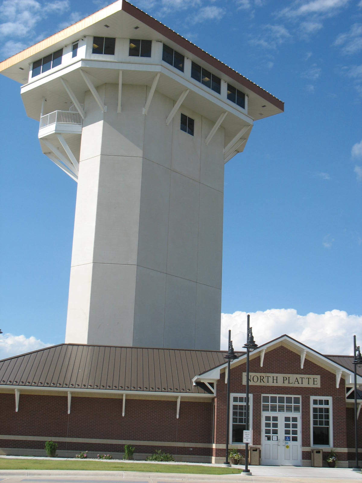
After being in small towns for so long, North Platte (pop. About 20,000) was incredibly busy and crowded. It’s apparently a major tourist stop for those heading off to or coming from the vastness of western Nebraska and the RV park was pretty much full up by the end of the evening. For us, North Platte itself was a destination, specifically the Golden Spike Tower, an observation tower built for viewing the UP Railroad’s Bailey Yard, the “largest rail classification yard in the world.”

Trains come in from all directions, the cars are disconnected and then reconnected into different consists depending on the ultimate destination for the cargo. This car goes to Chicago, this one goes to Atlanta, and so on. There is also a huge locomotive maintenance facility with the big diesels lined up in rows, each awaiting their turn. You need to be a real railfan to spend a lot of time watching this happen, kind of like grass growing, but it’s interesting to have seen.

It turns out that the Golden Spike Tower, eight stories high, is built on private land next to the railyard and the UPRR wasn’t too happy about it. In a field next to the tower, corn had been planted in a pattern to resemble a steam locomotive. It was too big to get in all at once with my camera, but in this shot you can make out that the loco was headed toward the left with the cowcatcher in the bottom left corner.

North Platte was also the town that fed soldiers that were being moved on troop trains during WWII. There is a nice little memorial with a plaque right next to the railroad on the site of the canteen.

In the city park, a Challenger steam locomotive is on display, possibly the only one in the country. It is so huge that it would dwarf a modern locomotive.

We made another foray into regional food which involved going to one of the Runza restaurants in North Platte. The quintessence of the region is contained in a Runza which seems to be available in all but the smallest towns in Nebraska. It turns out to be a bun-like object with a filling that features onions and cabbage along with ground meat. I ordered the Swiss and mushroom variation. It tasted like something my mother might have made—nice and gooey, with notes of salt and Swiss, so completely homogenized that any taste of onion or cabbage was totally submerged in the overall blandness of the creation. I did spot a slice of mushroom. So American, these foods with no texture, no natural flavor, but handy to eat while driving a car or at the office. The restaurant was doing a great business with cars lined up at the drive-thru window, another great American invention (or should I say, oil-company invention?)
Valentine, Nebraska, up near the border with South Dakota, is way too small to have a Runza restaurant but it boasts an amazing number of canoe outfitters. Canoeing on the Niobrara River was something that we had been dreaming about since we had driven through Valentine eight years before. Our timing then was unfortunate, because we were there the day after Labor Day and the canoe outfitters were all closed up for the season. This time, our timing was only mildly off, since we wanted a canoe for a Saturday, the busiest day of the week for the outfitters. Nevertheless, we were on the river by 9 am and floating serenely through the Niobrara Wildlife Refuge. There were a lot of folks at the put-in point but the river separates everyone out quickly. The Refuge was filled with birdsong although except for turkey vultures and crows, we didn’t see any from the river. The river was moving at something like 4 – 7 miles an hour, so a person didn’t have to do much paddling except to avoid obstructions. However, there are times when you wish the river wasn’t moving even that fast, like when you have to make a decision on how to navigate a rock garden and the river keeps pushing you closer and closer, decision or not. We scraped bottom a few times but didn’t bounce off any rocks. In most places the river is pretty shallow, although I’d just as soon not capsize anyway.
When we booked our trip, the young lady in the office emphasized that if we wanted to go through the Refuge, we could have no alcohol, no water balloons and no water guns. When we trooped out to the van that would deliver us along with our canoes to the put-in point, a large trailer was being filled with huge inner-tube style floats. After floating through the Refuge, we came to a put-in spot and understood both the restrictions and the floats. This was party city. Floats were being launched as fast as they could be put in the water at the narrow access. Since the river was so shallow, the partiers could just hop off and walk their vessel to wherever, and most of them were joining up in large rafts of ten to twelve floats, complete with special floats to accommodate coolers. Now we didn’t have to navigate through rocks and shoals, we had to avoid drunken floaters with water cannons. Everyone was good natured so early in the day and we only took one shot of friendly fire, but it was definitely not a place for old fogies in canoes. Unless they were dirty old men, because there was a lot of flesh on display. Definitely a cultural experience. I suspect that there were lots of young folks with massive hangovers and skins the color of lobsters the next day. Fortunately, this was at the end of the trip and we could enjoy the memories of the peaceful Refuge.

Several times on the trip so far we have encountered concentrations of dragonflies, but nothing like we saw in north-central Nebraska. These were huge creatures, their transparent wings tipped with black that made it easier to observe their wingbeat patterns. We sat out one evening and just watched them swarm around, filling the air. Knowing practically nothing about dragon flies, I assume they were catching something smaller than them in the air, especially since they would abruptly change directions, just like the swallows that were swarming at a higher elevation. It made me dizzy to watch them. Another kind of dragonfly we saw regularly looked like it had been dipped in gold, even the lace of its wings. A third kind had eyes like lumpy turquoise and a body that looked like it was constructed using teeny-tiny bamboo. Because they like to land on me, I often have a chance to observe them closely. At least they don’t bite like the mosquitoes who also like to land on me and which have been amazingly absent on this trip.
The next day, Al took a short ride on the Cowboy Trail, Nebraska’s answer to the Katy Trail in Missouri. Unfortunately, being in Nebraska, the Cowboy trail doesn’t have the nice shady sections to offer, but it does have a long high trestle over the Niobrara as you can see in the photos.


We returned to the Niobrara Wildlife refuge to try to find the bison herd which had eluded us on our previous visit. As you can see in this photo, finding them was not a problem, although staying a safe distance was problematic. The little prairie dog sat across the road, warily watching both us and the bison.